Precision Mapping and Digital Survey Solutions for Construction Projects
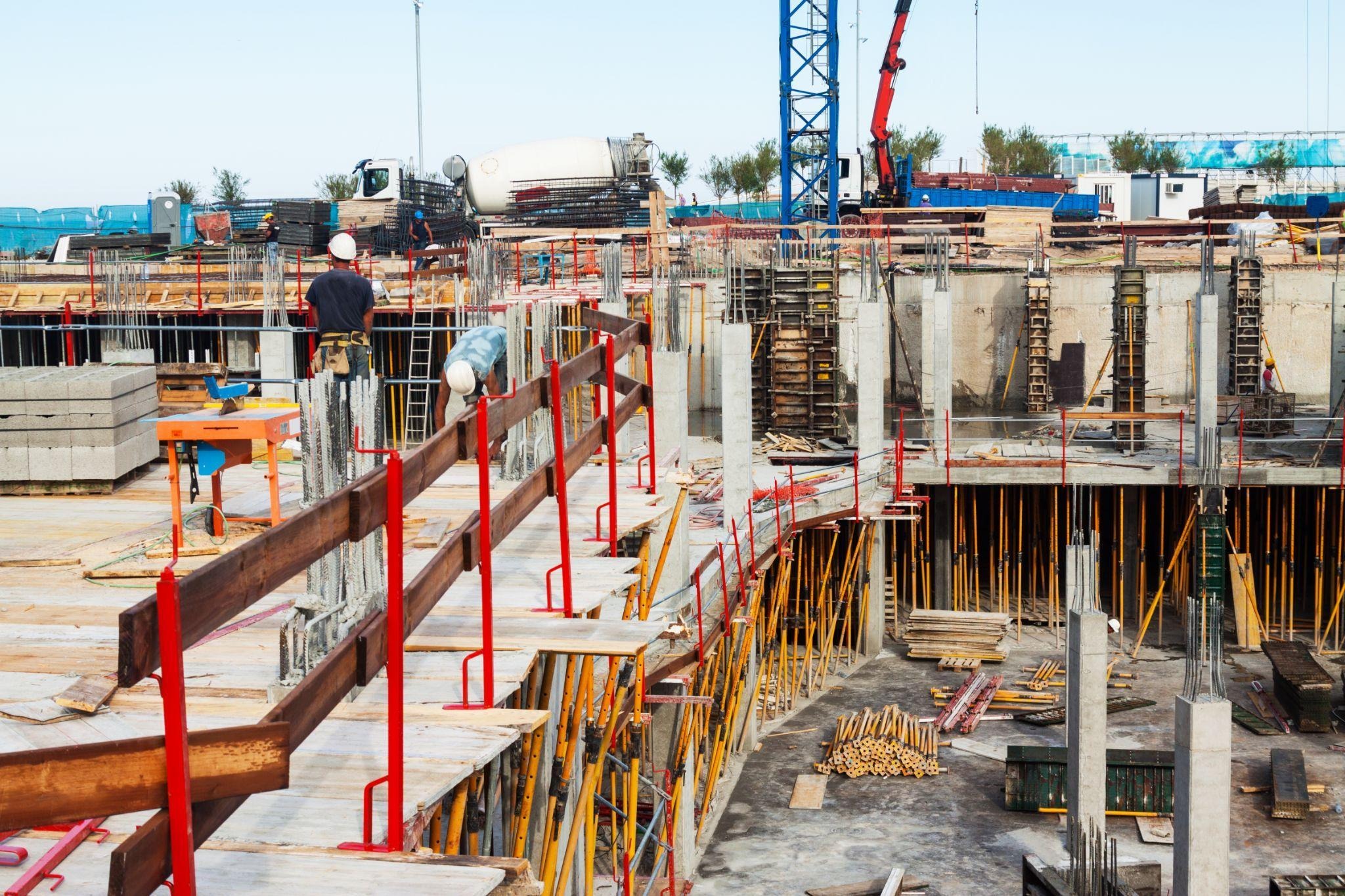
Construction, infrastructure, and industrial developments rely heavily on accurate site intelligence before execution begins. Advanced surveying methods now allow engineers, architects, and project managers to collect highly detailed measurements without interrupting ongoing operations. Modern digital capture methods support planning accuracy while reducing delays caused by manual measurement limitations.
Large-scale developments across the UAE increasingly depend on advanced reality capture solutions for documentation and analysis. High-resolution point cloud generation, structural assessment, and spatial modeling help teams coordinate complex environments with greater efficiency. Many engineering firms now integrate a scanning system into project workflows to improve precision during design validation and facility management processes.
Why Digital Surveying Has Become Essential for Modern Projects
Traditional measurement methods often struggle when dealing with complicated structures, congested utility corridors, or large industrial facilities. Digital survey solutions provide rapid data acquisition while maintaining exceptional measurement consistency across extensive environments. This helps engineering teams make informed decisions during planning and execution stages.
Accurate digital records also minimize rework during construction and renovation activities. Detailed spatial documentation enables consultants to identify clashes, verify dimensions, and streamline coordination among multiple stakeholders. As projects become increasingly sophisticated, dependable survey data plays a greater role in maintaining timelines and operational efficiency.
High-Accuracy Data Collection Supports Better Planning
Precise measurements form the foundation of successful engineering and architectural projects. Laser-based survey equipment captures millions of spatial reference points within minutes, producing comprehensive digital models suitable for design verification and construction coordination. These datasets assist project teams in evaluating existing site conditions with remarkable detail.
Reliable site information reduces uncertainty during planning phases. Engineering consultants can analyze structures, utilities, and elevation profiles before initiating physical work. This improves communication between contractors, designers, and authorities while supporting smoother approval processes for large developments.
Enhanced Spatial Documentation
Highly detailed point cloud records allow engineers to evaluate structures from multiple perspectives without repeated site visits. These digital references improve project accuracy and support long-term documentation requirements for infrastructure assets.
Faster Capture of Complex Environments
Industrial plants, airports, and utility corridors often contain dense layouts that are difficult to measure manually. Advanced survey equipment rapidly records these environments while maintaining dependable dimensional consistency.
Reduced Human Measurement Errors
Manual surveying procedures may introduce inconsistencies during fieldwork. Automated digital capture minimizes discrepancies by collecting precise geometric information directly from the physical environment.
Improved Coordination Between Disciplines
Architects, MEP consultants, and structural engineers benefit from unified spatial datasets. Shared digital models simplify collaboration and help teams resolve conflicts before construction activities begin.
Applications Across Construction and Infrastructure Projects
Survey technology now supports numerous industries, including commercial construction, transportation, oil and gas, utilities, and urban planning. Accurate digital models assist professionals during feasibility studies, redevelopment planning, and maintenance operations. Complex environments can be analyzed with greater clarity using detailed visual datasets.
Infrastructure authorities also depend on digital survey information to improve asset management strategies. Roads, bridges, tunnels, and public utilities require accurate documentation for inspection and expansion purposes. Reliable data contributes to safer operational planning and more effective lifecycle management.
Utility Mapping and Underground Detection Services
Underground infrastructure presents significant risks during excavation and construction activities. Utility detection surveys help identify pipelines, electrical networks, and communication systems before ground disturbance begins. Accurate mapping prevents accidental damage and improves site safety conditions.
Comprehensive underground assessments also support regulatory compliance and engineering coordination. Project teams can develop excavation strategies with greater confidence when hidden utilities are properly documented. This minimizes operational disruptions and reduces the likelihood of costly delays during construction.
Reality Capture Improves Renovation and Retrofit Projects
Existing buildings frequently require modernization, expansion, or structural upgrades. Digital reality capture techniques provide accurate representations of current site conditions before renovation begins. This information helps consultants design modifications without relying on outdated drawings or incomplete records.
Detailed digital models also support prefabrication workflows for retrofit projects. Components can be manufactured according to verified dimensions, reducing installation challenges on-site. Renovation teams benefit from improved planning accuracy and smoother coordination throughout execution stages.
Accurate As-Built Documentation
Completed structures often differ slightly from original design plans. Detailed as-built surveys provide dependable records of actual site conditions for future maintenance and renovation activities.
Safer Assessment of Difficult Locations
Certain industrial environments may involve restricted access or hazardous conditions. Remote measurement technology enables professionals to capture spatial data without prolonged exposure to operational risks.
Better Facility Management Support
Digital building records simplify maintenance planning and asset tracking. Facility managers can reference accurate spatial information during inspections, upgrades, and operational assessments.
Integration With BIM and Engineering Workflows
Modern survey datasets integrate effectively with Building Information Modeling platforms and engineering software. Point cloud information can be converted into intelligent 3D models that assist design coordination and project visualization. These workflows support improved communication among stakeholders across multiple project stages.
Engineering consultants also benefit from enhanced analytical capabilities through digital modeling integration. Structural evaluations, clash detection, and quantity verification become more efficient when precise survey data is available. Coordinated digital environments help reduce uncertainty during planning and execution.
- Supports accurate BIM model development
- Improves interdisciplinary coordination
- Simplifies clash detection processes
- Assists quantity verification activities
- Enhances project visualization accuracy
Advanced Equipment Enhances Survey Performance
Modern laser scanners and reality capture tools deliver exceptional performance across large and detailed environments. High-speed equipment captures dense datasets while maintaining consistent measurement reliability. Advanced imaging capabilities further improve visualization and documentation quality for engineering applications.
Portable systems also allow survey teams to operate efficiently in challenging conditions. Compact equipment supports mobility across construction sites, industrial facilities, and infrastructure corridors. Combined with specialized software, these technologies streamline data processing and project delivery timelines.
- High-density point cloud generation
- Rapid capture of extensive environments
- Portable equipment for site flexibility
- Detailed imaging for visual analysis
- Reliable measurements for engineering tasks
Final Thoughts
Could engineering projects achieve higher precision without dependable digital site intelligence? Accurate survey data now plays a vital role in reducing construction risks, improving collaboration, and supporting informed decision-making across complex developments. Through advanced surveying solutions, LYCA Surveying continues to assist infrastructure, industrial, and commercial projects with highly detailed spatial documentation and engineering support. Their expertise in 3D laser scanning technology in Dubai helps project teams maintain accuracy, efficiency, and operational confidence throughout every stage of development.